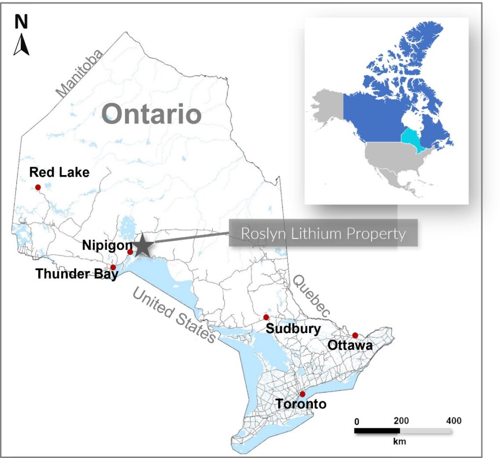
The Roslyn Lithium Property located 50 km northeast of Nipigon, northwestern Ontario (Figure 1). The Property is located 20 km southeast of the Georgia Lake Pegmatite Field and 35 km southeast of where Rock Tech Lithium just published a PEA supporting the indicated mineral resource of 10.6 Mt (million tonnes) grading 0.88% Li2O and an inferred mineral resource of 4.2 Mt grading 1.0% Li2O
https://www.rocktechlithium.com/news/georgia-lake-project:-pre-feasibility-study-published.
To view an enhanced version of this graphic, please visit:
https://images.newsfilecorp.com/files/5737/146883_8d70cb22d403eb12_001full.jpg
Roslyn Lithium Project
The Property consists of 12 claims (254 cells) comprising 5,100 hectares. The following salient features make the Property a high merit for hosting lithium-bearing pegmatites:
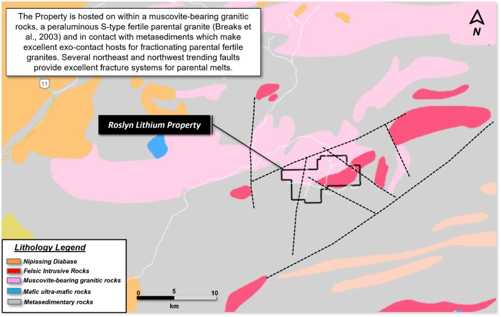
1) A muscovite-bearing granite is host to the Property, an S-type peraluminous fertile parental granite according to Breaks et al., 20031 and in contact with metasediments which make excellent hosts for pegmatites. Numerous faults transect the Property providing excellent pathways for granitic melts and evolving pegmatites (Figure 2).
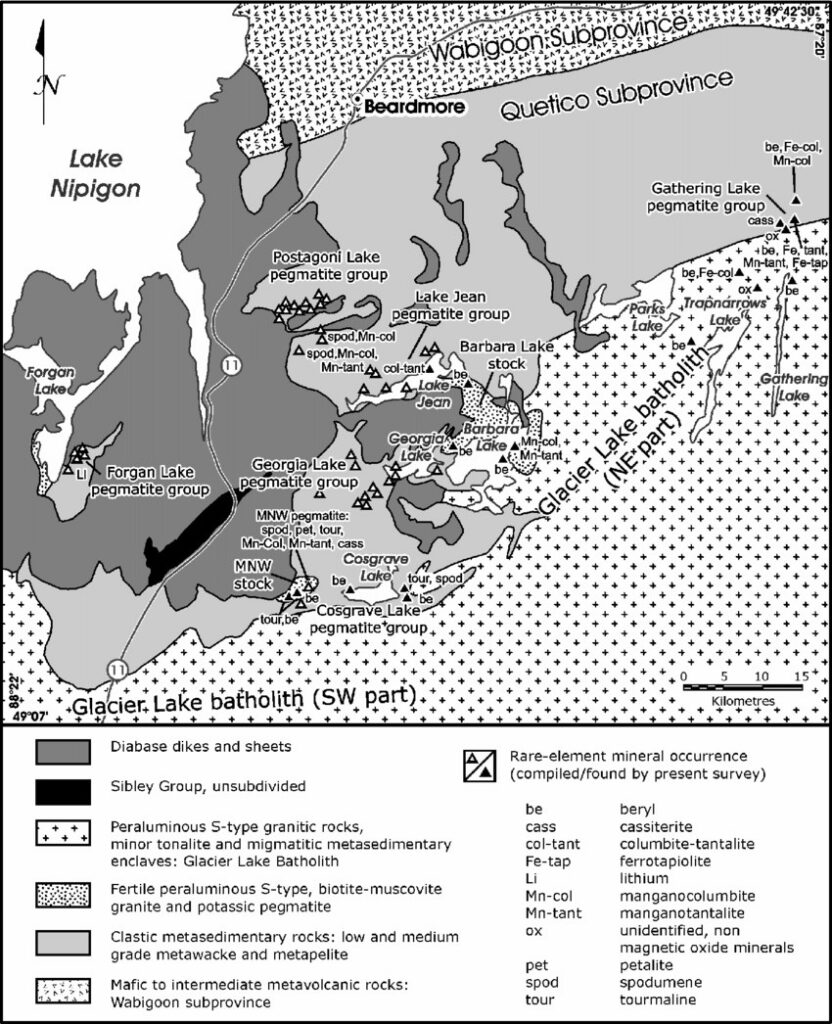
2) The Roslyn Lithium Property sits approximately 35 km southeast of the Georgia Lake Pegmatite field where several lithium deposits and occurrences are being explored and developed by Rock Tech Lithium, Ultra Lithium and Infinite Ore Corp. (Figure 3).
3) Breaks et al., 20082 described the Georgia Lake pegmatite field as the largest concentration of rare element mineralization in the Superior Province. The 32 x 105 km pegmatite field hosts 38 rare-element occurrences and 10 spodumene pegmatite deposits and occurrences. Breaks added that further exploration is recommended (Figure 4).
4) Several white pegmatites with garnet and tourmaline have been documented and mapped on the Property by the OGS in 1970 (Ontario Department of Mines map M2293). These are very good indications of fertile granitic melts.
5) The Property has logging road access from the Trans-Canada Highway 11.
To view an enhanced version of this graphic, please visit:
https://images.newsfilecorp.com/files/5737/146883_8d70cb22d403eb12_002full.jpg

To view an enhanced version of this graphic, please visit:
https://images.newsfilecorp.com/files/5737/146883_8d70cb22d403eb12_003full.jpg
To view an enhanced version of this graphic, please visit:
https://images.newsfilecorp.com/files/5737/146883_8d70cb22d403eb12_007full.jpg
References
-
- Breaks, F.W., Selway, J.B. and Tindle, A.G. 2003. Fertile peraluminous granites and related rare-element mineralization in pegmatites, Superior Province, northwest and northeast Ontario: Operation Treasure Hunt; Ontario Geological Survey, Open File Report 6099, 179p.
- Breaks, F.W., Selway, J.B. and Tindle, A.G., 2008. The Georgia Lake Pegmatite Field and S-Type, Peraluminous Granites, Quetico Subprovince, North-Central Ontario. Ontario Geological Survey, Open File Report 6099, 211 p.